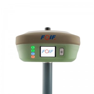
FOIF F90 GPS RTK receiver GINTEC F90 394 channels dgps GNSS RTK receiver geodetic surveying equipment


Key Features
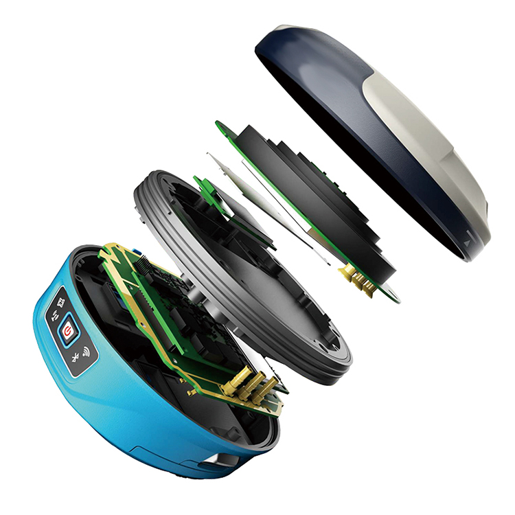
Multi-constellation satellite tracked
The world’s fifth-generation GNSS baseband chip TIANQIN, integrating 394 super channels, supporting multi-satellite system full-band satellite signal reception.
Athena core GNSS engine
Running Athena core GNSS engine offering improved initialization times, robustness in difficult environments, performance over long baselines and under scintillation.
Atlas
The receiver can receive our new GNSS global corrections service delivered via L-band satellite and internet to abtain centimeter-level positioning accuracy.
aRTK technology
Using aRTK technology to maintain positioning accuracy at a certain time when loss of GNSS has occurred.
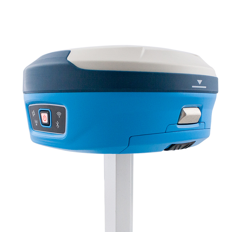
Combined antenna
Using a new combined antenna, GNSS, WiFi, Bluetooth and 4G are integrated into one, and the wireless signal is better.
Intelligent base station
After the base station is started, if a positional offset occurs, the mobile station is notified of the alarm.
Bulit-in 4G network module
More stable network communication.
Main Features:
1) 394 channels,
2) Tracking All constellations:
GPS: L1C/A, L1P, L1C, L2P, L2C, L5
GLONASS: G1, G2, P1, P2
BDS: B1, B2, B3
SBAS: LI C/A, L5
GALILEO: E1BC, E5A, E5B
L-BAND
3) Static: H: 2.5mm±1ppm, V: 5mm±1ppm
RTK: H: 8mm±1ppm, V:15mm±1ppm
4) Internal TX/RX UHF radio, the work range is 3-4KM.
5) 35W External radio: the work range is 20-30KM.
6) 4G network, WebUI, Wi-FI, iVoice intelligent, Bluetooth,
8) Strong software “Esurvey“, SurvCE, Field Genius, Fast Survey are supported too.
9) Dual batteries design, support hot swap, charging and external charging configurations.
10) Protocol: GeoTalk, SATEL, PCC-GMSK, TrimTalk, TrimMark, SOUTH
11) Data format: RTCM, CMR+, CRM, ROX, RTCA and etc. Can work with all the famous brand (Trimble, Leica, Topcon) all over the world
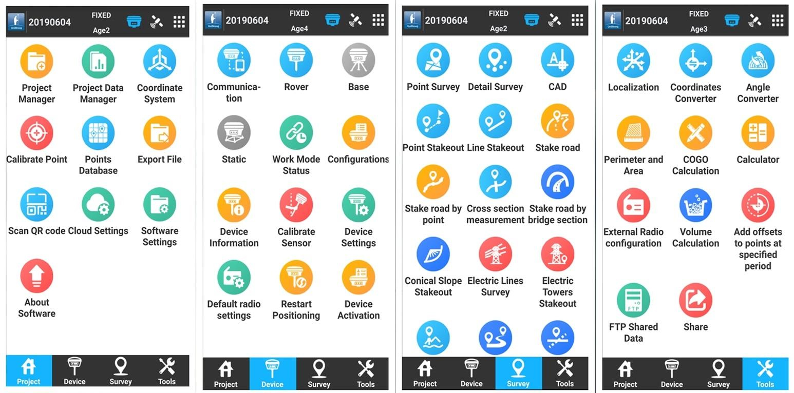
Carlson SurvCE/FieldGenius/Surpad
Surpad Software Professional,intuitive and efficient
This ESurvey RTK data controller Field Software is designed & developped by the most professional software R&D engineers team, which brings you a professional, intuitive and efficient measurement of the new experience. TheSurpad software integrates construction survey, power survey, GIS data collecting in one unit. This software is compatible both with Windows Mobile and Android platform, it also supports the smart phone to be used as data controller.
1. Power Survey
Line selection, cross measurement, 4-D Data Format output.
2. Road survey
Road design, Middle Side Stake Layout, Cross section survey.
3. Base Map Loading
Support vector data loading such as DXF, SHP and GCP.
4. GIS collection
Support Attribute Data Collecting by Self-Defined data dictionary and export GIS exchange format.
5. Post Processing Software GGO
Support to convert the data format into RINEX, which is compatible with AutoCAD and other Drawing & Mapping Software.
F90 Intelligent GNSS Receiver
| Items | Specification | |
| GNSS Engine | GNSS board | Trimble BD990 board |
| Channel | 336 | |
| Satellites | GPS: L1 C/A, L2E, L2C, L5 | |
| GLONASS: L1 C/A, L2 C/A, L3 CDMA14 | ||
| BeiDou: B1, B2, B313 | ||
| Galileo: E1, E5A, E5B, E5AltBOC, E614 | ||
| IRNSS: L5 | ||
| SBAS: L1C/A, L5 | ||
| QZSS: L1 C/A, L1 SAIF, L1C, L2C, L5, LEX | ||
| MSS L-Band: OmniSTAR, Trimble RTX | ||
| Tilt survey: The forth generation Tilt Technology, IMU function | ||
| Real-Time Accuracy(rms) | SBAS | Horizon: 60cm(1.97ft); Vertical: 120cm(3.94ft) |
| Real-Time DGPS position | Horizon: 40cm(1.31ft); Vertical: 80cm(2.62ft) | |
| Real-Time Kinematic Position | Horizon: ±( 8mm+1ppm) ; Vertical: ±( 15mm+1ppm) | |
| Real-Time Performance | Instant-RTK Intialization | Typically |
| Stop and Go solution | 99.9% reliability | |
| RTK Intialization range | >40km | |
| Post Processing Accuracy(rms) | Static, Rapid Static | Horizontal: 2.5mm(0.008ft) +1.0ppm; |
| Vertical: 5mm(0.016ft)+1.0ppm | ||
| Post-processing Kinematic | Horizontal: 10mm(0.033ft)+1.0ppm; Vertical: 20mm(0.066ft)+1.0ppm | |
| Solutions | Main function include: F90 GNSS Support: configuration, monitoring and control | |
| Field Software Suite | Volume computation | |
| Surpad software | Network connectivity, Coordinate System Support: predefined grid systems, predefined datums | |
| projections, Geoids, local grid | ||
| Map view with colored lines Geodetic Geometry: intersection, azimuth/distance, offsetting, poly-line, curve, area | ||
| Road Construction (3D): Survey Utilities: calculator, RW5 file | ||
| Viewing: Data import/Export: DXF, SHP, RW5 | ||
| Data logging | Recording Interval | 0.1-999 seconds |
| Physical | Flat design | |
| Size | 156mm*76mm | |
| Bottom cover | Aluminum magnesium alloy | |
| Memory | Internal memory | 8GB standard; supports extending to 32GB |
| I/O Interface | TNC port | connecting built-in radio antenna |
| 5-pin lemo port | connecting external power supply and external radio | |
| 7-pin lemo port | (USB+serial port): connecting PC and handheld | |
| Operating system | Linux | Based on Linux; Supports Web UI |
| Voice | Multi-language supported | |
| Tilt survey sensor | Automatic correct system by 30 degree | |
| Data format | Data format | RTCM 2.3 |
| RTCM 3.0.RTCM 3.X | ||
| CMR, CMR+ | ||
| NovAtelX/5CMRx | ||
| Operation | Operation | RTK rover/base, post-processing |
| RTK Network rover | VRS, FKP, MAC | |
| Point-to-point GPRS through Real-time Data | ||
| Server Software (internal GPRS or external cell phone) | ||
| LandXML (FOIF Field Genius support) | Total Station support ( FOIF Field Genius) | |
| Import and stake directly from a DXF File (FOIF Field Genius) | ||
| Office Software | Main functions include: Network post-processing | |
| Integrated transformation and grid system computations | ||
| Pre-defined datums along with use-defined capabilities | ||
| Survey mission planning | ||
| Automatic vector processing | ||
| Least-squares network adjustment | ||
| Data analysis and quality control tools | ||
| Coordinate transformations | ||
| Reporting | ||
| Exporting | ||
| Geoid | ||
| Environmental | Operating temperature | -30℃ to +65℃(-22°F to 149°F) |
| Storage temperature | -40℃ to +80℃(-40°F to 176°F) | |
| Humidity | 100% condensing | |
| Waterproof | IP67 (IEC60529) | |
| Shock | 2m (6.56ft) pole drop | |
| 1.2m (3.94ft) free drop | ||
| Power | 7.2v.2 removable batteries (total up to 6800mAh, supports single battery working) | |
| Optional System Components | Communication Module | Internal radio: UHF Link (410-470MHz) |
| 1W | ||
| External radio | R*&*both (5w/35w selectable) | |
| 4G LTE module (EC25 series) | Fits various networks | |
| blue tooth | 2.1+EDR Class 2 | |
| WiFi | IEEE 802.11 b/g/n | |
| Antenna | Built-in antenna, integrating GNSS, BT/WLAN and network antenna | |
| Controller | F58 | |
Products categories
-
Foif A80 Cheap Handheld Land Survey Equipment H...
-
Gnss Receiver Landing Gps Survey Equipment RTK ...
-
Land surveying instruments with 555 channels gn...
-

FOIF A90+A70 AR Gps Rtk Base And Rover Gnss Sur...
-
Surveying Equipment Foif A90 GNSS Gps Rtk
-

FOIF A70 AR Dual Frequency GNSS Dgps Instrument...