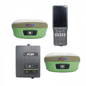
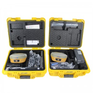
Gnss Receiver Landing Gps Survey Equipment RTK Foif A60 Pro
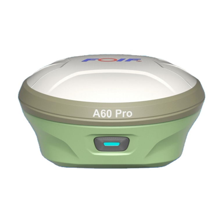


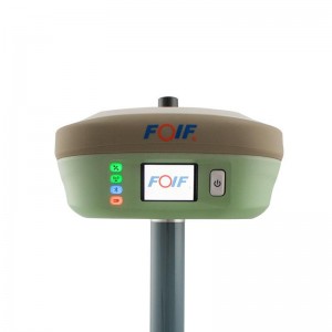
A60 PRO Intelligent GNSS Receiver
•Compact design, more productive.
•professional GNSS satellites tracked simultaneously.
(GPS,Glonass,Galileo,Beidou)
•Automatic data collection during centering.
•When the pole is tilted in 30 degrees, A60 PRO still could get the right point data by automatic correct system.
•Applies WIFI connection to realize WebUI control designed to modify settings and monitor the receiver status.
•Bundled Android field software brings a big change in user experience and accessibility.
Top Features
1) Smart Design
With the increasing demand for smart-design GNSS, to develop the receiver featured with miniaturization turns into our new goal until today it comes true.
It is completely no doubt that small size and light weight design can greatly alleviate general field work and improve productivity a lot.
Carlson SurvCE/FieldGenius/Esurvey/SurPAD
Surpad Software Professional,intuitive and efficient
This RTK data controller Field Software is designed & developped by the most professional software R&D engineers team, which brings you a professional, intuitive and efficient measurement of the new experience. The ESurvey software integrates construction survey, power survey, GIS data collecting in one unit. This software is compatible both with Windows Mobile and Android platform, it also supports the smart phone to be used as data controller.
1. Power Survey
Line selection, cross measurement, 4-D Data Format output.
2. Road survey
Road design, Middle Side Stake Layout, Cross section survey.
3. Base Map Loading
Support vector data loading such as DXF, SHP and GCP.
4. GIS collection
Support Attribute Data Collecting by Self-Defined data dictionary and export GIS exchange format.
5. Post Processing Software GGO
Support to convert the data format into RINEX, which is compatible with AutoCAD and other Drawing & Mapping Software.
| A60 PRO | ||
| GNSS | Channels | 800 |
| Satellite Signals | GPS:L1 C/A,L1P,L1C,L2C,L2P,L5 | |
| BDS: B1I, B2I, B3I, B1C, B2a, B2b, ACEBOC | ||
| GLONASS: G1, G2, G3 | ||
| Galileo: E1, E5a, E5b, ALTBOC, E6 | ||
| QZSS: L1C/A, L1C, L2C, L5, LEX | ||
| SBAS:L1,L5 | ||
| L-Band: optional | ||
| Update Rate | 10Hz standard, 20Hz optional | |
| Accuracy | Static | H: ±(2.5+0.5×10⁻⁶D)mm ; V: ±(5+0.5×10⁻⁶D)mm |
| RTK | H: ±(8+1×10⁻⁶D)mm; V: ±(15+1×10⁻⁶D)mm | |
| Power supply | Battery capacity | Built-in battery, 4.2V, 6800mAh*2 |
| working duration | lasts for 10h (rover) | |
| input voltage | 9~28V DC | |
| System | Operating System | Linux+A7 |
| Memory | 8G, no TF card slot | |
| blue tooth | V5.0+EDR, downward compatibility/ BLE | |
| WIFI | 802.11 b/g/n | |
| Network | Full Netcom 4G; | |
| LTE FDD: B1/B3/B5/B8 LTE TDD: B34/B38/B39/B40/B41 WCDMA: B1/B8 TD-SCDMA: B34/B39 CDMA: BC0 GSM: 900/1800MHz |
||
| radio | TRM101,410-470MHz | |
| RTKFusion | Positioning accuracy of 30° bar tip within 2cm and 60° bar tip within 5cm Note: 1.8 m bar height | |
| Data link | TNC | used to connect inner radio antenna |
| Type-C port | used for charge and date transmission | |
| 5 Pin Port | Used to connect external power and external radio | |
| Esim | ESim embedded, no need to insert a card can be implemented network mode operation | |
| SIM Card slot | Dual-card slot compatible design, embedded ESIM, external SIM card.If the SIM card is inserted, it will use the SIM card by default. If the SIM card is not inserted, it will use ESim by default.At the same time, the user can also choose the use scheme | |
| Physical | Size | 148mm*74.5mm, weights about 1.0kg |
| vioce | supprt | |
| Screen | Smart Touch Screen, work as a controller | |
| Physical | Size | 148mm*74.5mm, weights about 1.0kg |
| vioce | supprt | |
| Screen | Smart Touch Screen, work as a controller | |
| turn on/ off | 1) Long press for 3 seconds to turn off the device. (2) Short press once to broadcast the current state, and the four battery level indicator lights will be on for 5s according to the battery level and then off. Shutdown state: (1) Long press for 3 seconds to start the device (2) Shutdown and charging state: four battery level indicators. (3) Short press once (slightly longer than in the power-on state) : the four battery level indicator lights will be on for 5s and then go off. |
|
| Breathing Light Red Red always bright: self - check fault Breathe in Red: Charge less than 25% Red flash: abnormal communication on board card Green 5S one time (500ms green) overlay mixed color: data records, including static, base station, mobile station data records purple Chang Liang: Fixed solution Blink: data link receiving and sending Breathing: single point, successful positioning |
||
| Flash: Not positioned Purple turns blue when blue tooth is connected Yellow boot in.. Yellow flicker self check.. The yellow breath firmware is being upgraded.. Red-green-blue cycle built-in module upgrade...Including network module firmware, board card firmware, sensor firmware, radio firmware 4 electric quantity indicator lights In the charging state, the light flashes according to the remaining charge 75% to 100% electric quantity, representing 25%/50%/75% electric quantity light is always green, only the fourth electric quantity light flashes The battery level is 50%-75%, representing 25% and 50% of the battery level lights are always green, and only the third battery level light flashes The battery level is 25%-50%, representing 25% of the battery level light is always green, and only the second battery level light flashes When the battery is below 25%, only the first battery light flashes every second Power 75-100%, 4 lights are all bright, green is always bright Power 50%-75%, 3 lights on, green light Electricity 25%-50%, 2 lights on, green light is always on When the electric quantity is lower than 25%, only one light is left and the green light is always on |
||
| Environment | Work Temperature | -30℃ ~ +65℃ |
| Storage | '-40℃ ~ +80℃ | |
| Temperature | ||
| Down Fall | Resistance to 2m fall with pole (hardwood ground), 1.2m free fall. | |
| Waterproof & dustproof | IP67 | |
| Humidity | anti-condensation 100% | |
Products categories
-
FOIF F90 GPS RTK receiver GINTEC F90 394 channe...
-
Foif A80 Cheap Handheld Land Survey Equipment H...
-

FOIF A90+A70 AR Gps Rtk Base And Rover Gnss Sur...
-

FOIF A70 AR Dual Frequency GNSS Dgps Instrument...
-
Surveying Equipment Foif A90 GNSS Gps Rtk
-
Land surveying instruments with 555 channels gn...