| Specification |
| GNSS Features |
Channels |
336, 965 (optional) |
| GPS |
L1C/A, L1C, L2C, L2E, L5 |
| GLONASS |
L1C/A, L1P, L2C/A, L2P, L3 |
| BDS |
B1, B2, B3 |
| GALILEOS |
E1, E5A, E5B, E5AltBOC, E6 |
| SBAS |
L1C/A, L5 (Just for the satellites supporting L5) |
| IRNSS |
L5 |
| QZSS |
L1C/A, L1 SAIF, L2C, L5, LEX |
| MSS L-Band |
Trimble RTX[1] |
| Positioning output rate |
1Hz~50Hz |
| Initialization time |
< 10s |
| Initialization reliability |
>99.99% |
| Positioning Precision |
Code differential GNSS positioning |
Horizontal: 0.25 m + 1 ppm RMS |
| Vertical: 0.50 m + 1 ppm RMS |
| GNSS static |
Horizontal: 2.5 mm + 0.5 ppm RMS |
| Vertical: 5 mm + 0.5 ppm RMS |
| Real-time kinematic |
Horizontal: 8 mm + 1 ppm RMS |
| (Baseline<30km) |
Vertical: 15 mm + 1 ppm RMS |
| SLink (RTX)[2] |
Horizontal: 4-10 cm |
| Vertical: 8-20 cm |
| RTK XTRa (xFill)[3] |
Horizontal: 5 + 10 mm/min RMS |
| Vertical: 5 + 20 mm/min RMS |
| SBAS positioning |
Typically<5m 3DRMS |
| RTK initialization time |
2~8s |
| IMU tilt compensation |
Additional horizontal pole tip uncertainty typically less than 8mm + 0.6 mm/° tilt down to 30° |
| IMU tilt angle |
0°~60° |
| Hardware Performance |
Dimension |
15.3cm(φ)×10.6cm(H) |
| Weight |
1.2kg (battery included) |
| Material |
Magnesium aluminum alloy shell |
| Operating temperature |
-25℃~+65℃ |
| Storage temperature |
-35℃~+80℃ |
| Humidity |
100% Non-condensing |
| Waterproof/Dustproof |
IP68 standard, protected from long time immersion to depth of 1m IP68 standard, fully protected against blowing dust |
| Shock/Vibration |
Withstand 2 meters pole drop onto the cement ground naturally |
| Power consumption |
2W |
| Power supply |
6-28V DC, overvoltage protection |
| Battery |
7.4 V 3400mAh rechargeable, |
| removable Lithium-ion battery |
| Battery life |
Single battery: 16h (static mode) |
| 10h (internal UHF base mode) |
| 12h (rover mode) |
| Communications |
I/O Port |
5PIN LEMO external power port + Rs232 |
| 7PIN LEMO +external USB(OTG)+Ethernet |
| 1 UHF antenna interface |
| 1 GPRS antenna interface (internal and external antenna switchable) |
| SIM card slot (standard) |
| Internal UHF |
Radio receiver and transmitter, |
| 1W/2W/3W switchable |
| Frequency range |
410-470MHz |
| Communication protocol |
Farlink, Trimtalk450s, SOUTH, SOUTH+,SOUTHx, HUACE, Hi-target, Satel |
| Communication range |
Typically 15km with Farlink protocol |
| Cellular mobile network |
Advanced 5G network communication module, downward compatible with 4G/3G |
| Ble |
BLE 4.0 standard, 2.1+EDR |
| NFC Communication |
Realizing close range (shorter than 10cm) automatic pair between receiver and controller(controller requires NFC wireless communication module else) |
| WIFI |
Modem |
802.11 b/g standard |
| WIFI hotspot |
Receiver broadcasts its hotspot form web UI accessing with any mobile terminals |
| WIFI datalink |
Receiver can transmit and receive correction data stream via WiFi datalink |
| Data Storage/Transmission |
Storage |
64GB SSD internal storage |
| Automatic cycle storage (The earliest data files will be removed automatically while the memory is not enough) |
| Support external USB storage |
| The customizable sample interval is up to 50Hz |
| Data transmission |
Plug and play mode of USB data transmission |
| Supports FTP/HTTP data download |
| Data format |
Differential data format: CMR+, sCMRx, RTCM 2.1,RTCM 2.3, RTCM 3.0, RTCM 3.1, RTCM 3.2 |
| GPS output data format: NMEA 0183, PJK plane coordinate, Binary code, Trimble GSOF |
| Network model support: VRS, FKP, MAC, fully support NTRIP protocol |
| Sensors |
Electronic bubble |
Controller software can display electronic bubble, checking leveling status of the carbon pole in real-time |
| IMU |
Built-in IMU module, calibration-free and immue to magnetic interference |
| Thermometer |
Built-in thermometer sensor, adopting intelligent temperature control technology, monitoring and adjusting the receiver temperature |
| User Interaction |
Operating system |
Linux |
| Buttons |
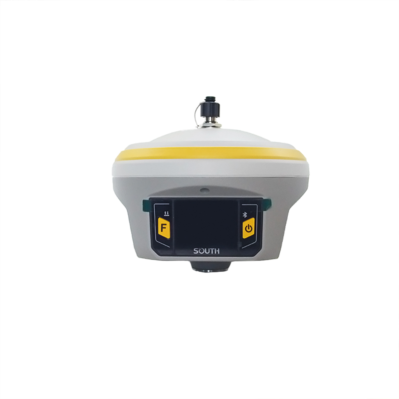
2-button and visual operation interface |
| Indicators |
2 LED indicators, data interaction indicator and indicator |
| LCD |
1.54-inch HD color LCD touch screen with resolution 240*240 |
| Web interaction |
With the access of the internal web interface management via WiFi or USB connection, users are able to monitor the receiver status and change the configurations freely |
| Voice guidance |
The intelligent voice technology provides status and operation voice guidance, supports Chinese/English/Korean/Spanish/Portuguese/Russian/Turkish |
| Secondary development |
Provides secondary development package, and opens the OpenSIC observation data format and interaction interface definition |
| Cloud service |
The powerful cloud platform provides online services like remote manage, firmware update, online register and etc |