Content of the project
The i73 GNSS receiver and the LandStar7 surveying application from Haodi were used by Thai clients to survey their farmlands. The scope of the project was to subdivide the land into different parcels to meet the requirements of subsistence farming. The i73 GNSS receiver and LandStar7 were used by the surveyors to stake out and delineate the parcels boundaries.

What’s the purpose of land allocation?
In the mid-20th century, the King Bhumibol of Thailand initiated the Philosophy of Sufficiency Economy to help Thai farmers optimize their farmland. The King Bhumibol developed this concept as a system of integrated and sustainable agriculture, embracing his thoughts and efforts in water resource development and conservation, soil rehabilitation and conservation, sustainable agriculture and self-reliant community development.
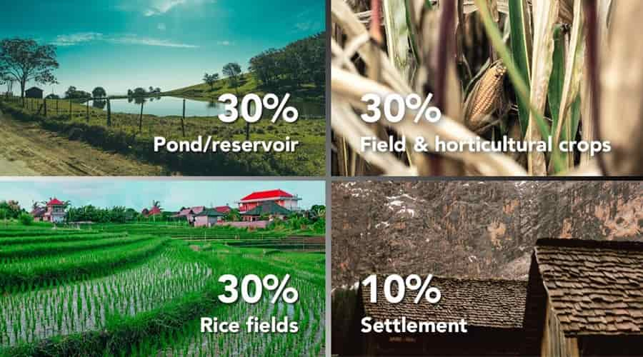
Following this concept, the farmers divided the land into four parts with a ratio of 30:30:30:10. The first 30% is intended for a pond; the second 30% is set aside for rice cultivation; the third 30% is used for growing fruit and perennial trees, vegetables, field crops and herbs for daily consumption; the last 10% is reserved for housing, livestock, roads and other structures.
How does GNSS technology increase the productivity of agricultural land allocation projects?
Compared to traditional surveying methods, the use of a GNSS solution allows for much faster project completion, from the initial CAD-based parcel allocation design to the physical staking out of boundaries in the field.
In the field, the Landstar7 App “Base Map” feature provides a clear and accurate display of the project’s extent, speeding up surveying operations and reducing potential errors. Landstar7 supports the import of DXF files generated from AutoCAD as well as other types of base maps, such as SHP, KML, TIFF and WMS. After importing the project data on top of a basemap layer, points or lines can be displayed, selected and staked out easily and accurately.
The i73, used for this project, is the latest pocket IMU-RTK GNSS receiver from Haodi. The unit is more than 40% lighter than a typical GNSS receiver, making it easier to carry and operate without fatigue, especially during hot seasons in Thailand. The i73 IMU sensor compensates for up to 45° pole-tilt, eliminating the challenges associated with surveying concealed or dangerous points to reach, which can be common in farmlands. The integrated battery provides up to 15 hours of field operation, allowing for full-day projects without worrying about power outages when working in more remote locations.
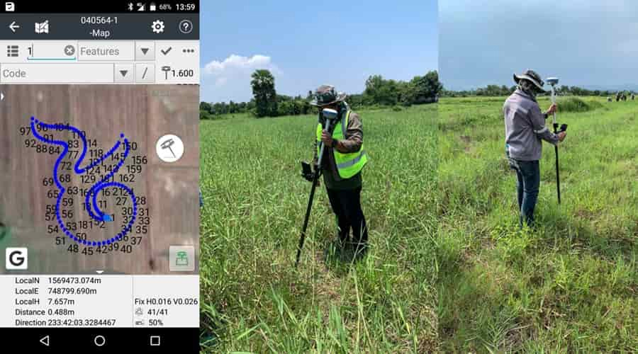
As a signature for this project, the operators traced the auspicious character “nine” in Thai, which is also the King Bhumibol’s Monarch number.
About Haodi Navigation
Haodi Navigation (Haodi) creates innovative GNSS navigation and positioning solutions to make customers’ work more efficient. Haodi products and solutions cover multiple industries such as geospatial, construction, agriculture and marine. With a presence across the globe, distributors in more than 100 countries and more than 1,300 employees, today Haodi Navigation is recognized as one of the fastest-growing companies in geomatics technologies. For more information about Haodi Navigation.
Post time: May-25-2022